Plane Table Surveying
Plane table surveying is one of the quick and easiest methods of surveying. The plane table surveying is a graphical method in which plotting of plans and field work are done at the same time. It is helpful for the following cases.
- It is suitable for small scale surveying and any type of field.
- It is used to survey the area where compass survey fails to perform.
- It is used to fill in details among stations fixed by triangulation methods.
- It is suitable for small and medium scale mapping (1:10,000 to 1:2,50,000).
Benefits of Plane Table Surveying
- The field observation and protting are done at same time, hence there is no risk of missing important details.
- The mistakes and errors in plotting can be checked by drawing check lines.
- This is suitable at magnetic areas where you can not perform compass surveys.
- Less time and less labour required.
- It is less costly than theodolite surveying.
- Irregular objects and contours can be represented accurately.
- Many skills are not needed to prepare a map.
- Survey can be completed very rapidly.
Drawbacks of Plane Table Surveying
- Plane table survey is not suitable in places with wet environments, high winds probability and in wooded country.
- Because of changes in temperature, the table is liable to distort.
- If sunlight is high, plotting can be hard due to strain on the eyes.
- It is not more accurate for large scale surveys as compared to theodolite and compass surveys.
- The plane table instrument and accessory are very heavy and they are likely to be lost.
- If the measurements are not maintained, it is difficult to calculate quantities or re-plot the survey to different scales.
Temporary Adjustments of the Plane Table
Centering
This process is to ensure that the point on ground is marked accurately on the paper. Centering process is executed with the help of a plumbing bob and plumbing fork. The pointed end of the plumbing fork is placed on paper and at the other end, a plumb bob is attached. The drawing board is moved manually until the plumb bob hangs perfectly over the peg of the station. This work can be laborious but a precondition for any further activities.
Levelling
Levelling process should be done because the board remains parallel to the ground surface. Levelling of the plane table should be done using spirit level. For small scale works, eye judgement can be ok.
Orientation
In the plane table surveying, the plane table requires to be shifted at various stations to complete the survey. So, orientation is the process in which the position of the plane table is kept parallel at several survey stations. Methods of orientation are as explained below.
Orientation by Magnetic Compass : This method is suitable when bisection of the previous station is not possible. This method is not suitable where magnetic effects occurred at the field.
Orientation by Back Sighting : This method is more reliable. In this method, a new line is drawn at a new survey station with reference to the old survey station.
Methods of Plane Table Surveying
Normally, four types of method to perform plane table surveying.
- Radiation
- Intersection
- Traversing
- Resection
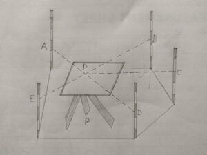
Radiation
In this method, the plane table is placed at one point “p” as shown in the photo and carries out the whole from that point. From point “p” sight all points such as A,B,C,D and E with help of alidade, locate and draw the points as a,b,c,d and e in the drawing paper.
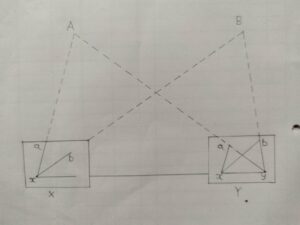
Intersection
In this method, the point is located by plotting two rays from two known stations. For example, X and Y are the known stations. First the plane table is placed on X and draws the line by sighting the stations A,B and Y. then move the plane table to station Y and draw the line by sighting stations A, B and X. Ultimately, intersection of A and B rays is the needed location of the point of intersection.
Traversing
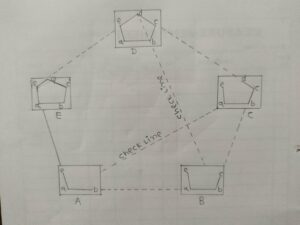
The steps for the method of traversing as given below.
- The place table is placed at a survey location A.
- From that survey location, a line of sight is taken in the direction of B and the distance AB is measured.
- The plane table is moved to survey station B and sighted in the direction of A (back sight system). BA distance was measured.
- The mean distance between AB and BA are plotted (with suitable scale) on the drawing sheet.
- Then, survey station C is sighten from survey station B and the distance was measured. This process is done again for all survey stations.
- Finally, plot lines of traverse on the drawing sheet. Please note that the back sighting process is done for only the first two survey stations.
You May Also Like : Total Station : Benefits and Features